This
map of the northern portion of the area shows a heavy black line that I have
drawn to show SaskPower's selected route. From all the alternatives available,
this selection destroys the MOST FOREST, comes close to MORE HOMES , and goes
through the MOST SENSITIVE areas. (Sensitive areas shown in red/ orange) In
its selection of where to go westward across the highway, it specifically targets
the area known as Friendly Forest. It needs to be noted that the forest area
is densely populated with most holdings of 16 hectares / 40 acres [ 1/4 mile
by 1/4 mile] while open areas (shown in yellow as low sensitivity) are large
farm holdings with very few and widespread dwellings. SaskPower NEVER seems
to accept that human residents are an important part of the environment that
is affected by their power corridors!
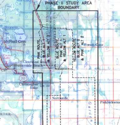
This
SaskPower map shows the final three options considered by SaskPower. They
have selected the "Pink" route to the left, and ignored the route
to the right. In doing so they have opted to push a huge corridor THROUGH
an intact forest rather than going OVER open
farm land away from peoples homes! A forest route in this area destroys 999
times as much land as a corridor over already opened land.
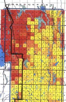
Each
square represents 160 acres (Quarter Section), and is ranked as to environmental
damage by a powerline corridor. A non-forest route would have an average negative
impact of 3 out of 16 as compared to a negative imact of 14 out of 16 when
going through the forest. This is SaskPower's own information!!
Forest of Protest Page 4