(Note: The
aerial photo was taken more than 25 years ago, sometime after parts
of the area were selectively logged. Since that time
I have built my home and shop and have developed the trails
shown in colour code above. The Highway shown is Highway No.
2 North, 40 KM north of Prince Albert Saskatchewan)
1. "Freedom
Way" is
a larger loop around the pond. Trees along this trail have been adorned
with abandoned neck ties from my former professional life. The Sacred
Hoop Trail has intersected Freedom Way and takes precedence. I
am letting the portions of Freedom Way which lie within the Hoop Trail
to revert to natural forest pattern. The section of Freedom Way closest to the Highway and to the south of my driveway was largely under water for several years. As of September 2011 an entirely new section of trail on higher ground has been created to restore the complete Freedom Way trail in this area.
2.. "Pond
Loop" circles the pond along a well established game trail. This
trail links to Freedom Way by numerous connecting "Pond Links". If
disoriented by twists and turns in the trail, taking one of these
links to the open area of the pond will enable the hiker to reestablish
orientation. In the spring and summer of 2006 much of this
trail is under water because of a dramatic increase in water levels.
Not advised without boots
3 "Thrum's
Run", named after a game trail that my former dog, Thrum, used to
follow daily to check on the deer that bedded down along that way.
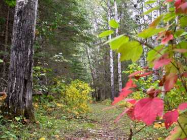
A very pretty and diverse trail, featuring the only jackpine area
on my site."King's Loop",
connects to Freedom Way and takes the hiker through both aspen
and spruce stands.
4
"Kings Loop" was the longest section of trail and
connected to Freedom Way at the South West and then extended
along the entire south border of the land and then ran northward
and west to reconnect to Freedom Way. The
entire east-west section of this line no longer exists because
of SaskPower's wanton destruction. As of early October 2011, an entirely new trail connector has been established to connect the east and west ends of the original Kings Loop Trail. This connector is north of the Power line corridor.
"King's
Link" ( in pink) provides a connector between King's Loop and Freedom
Way along a ridge, joining at a location called "Council of the
Elders"
5.
This is a new section created in 2006 to allow movement around the
south and east sides of the pond while remaining on higher
ground in the trees. This avoids getting wet feet along
the high water edge of the pond.
6. "Sacred
Hoop" trail is complete It is a large
Sacred Hoop / Medicine Wheel trail with a radius of 90 m. It
is centred on top of a hill. It intersects
various other trails. Walking this Hoop is intended to be a
prayer / spiritual undertaking. Encountering the beauty of
the forest and the forest creatures along its paths makes it very
difficult for it to NOT be a prayer experience. 6E is the East
Quadrant protected by Eagle, 6S is the South Quadrant protected
by Bison, 6W is the West Quadrant protected by Bear, and 6N
is the North Quadrant protected by Wolf. Eagle Camp
is situated just beside the East Gate.
HJ. This
is a junction location where trails come together in the form
of the letter H. It links a pond link crescent, Freedom Way,
and King's Loop.
The
black lines represent trails on my neighbour's property and should
not be used without explicit permission.